“Creating Water-Smart Landscapes" is Estonian Research Council research grant No. 1764, which runs from 01.01.2023 to 31.12.2027. The principal investigator of the project is Prof. Evelyn Uuemaa.
Project overview
The project focuses on planning of nature-based solutions (wetlands, riparian buffer strips) as mitigation of agricultural diffuse pollution. The objectives of the project are:
-
To create an environmental data cube containing the most important remote sensing, soil, and topographic data necessary for water quality modelling in Estonia, the Baltics, and Europe.
-
To identify agricultural pollution hotspots using machine learning models.
-
To find, through suitability analysis, locations in the landscape where it would be easiest to restore wetlands in agricultural landscapes and where to establish buffer strips along water bodies to use them in reducing nutrient runoff.
-
To create spatial data layers for landscape-level planning that help plan the restoration of wetlands and the establishment of buffer strips along water bodies in agricultural landscapes in such a way that they are most effective in reducing diffuse pollution and, at the same time, are not located on very fertile agricultural land.
People

Evelyn Uuemaa

Holger Virro
Merle Muru
Yonas Balcha
Marta Jemeljanova

Pamela Guaman Pintado
Results
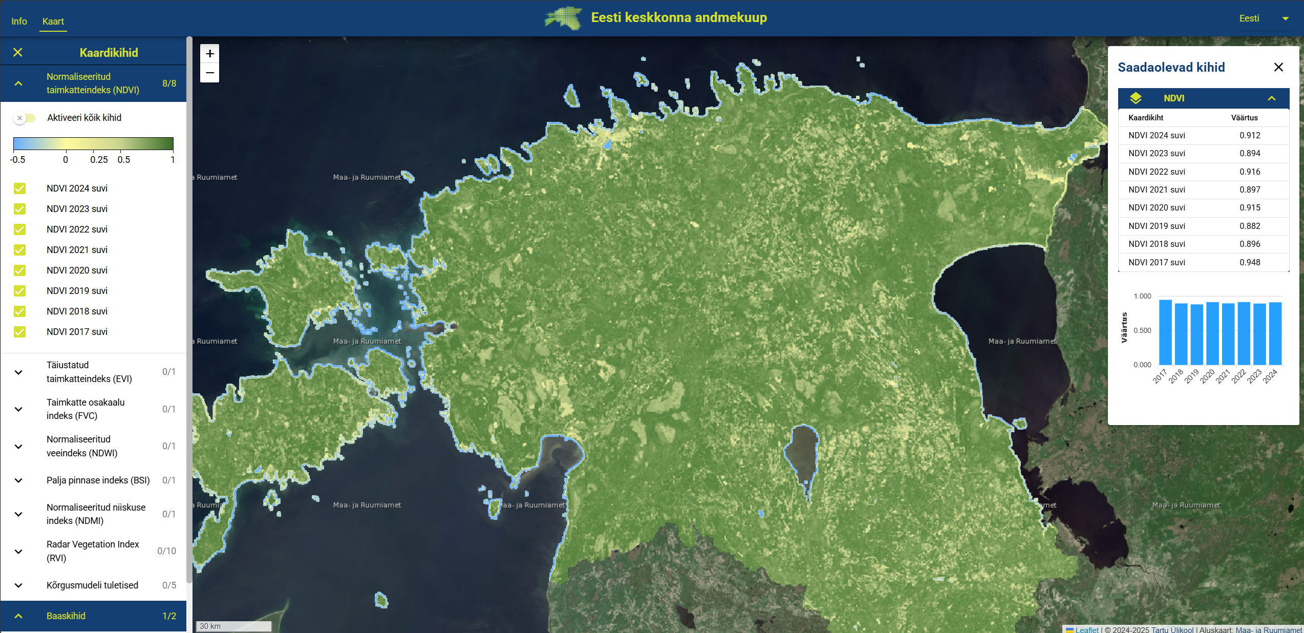
Estonian Environmental Data Cube
The Estonian Environmental Data Cube integrates various remote sensing data (Sentinel-1, Sentinel-2) and environmental data necessary for water quality modelling and the planning of nature-based solutions within the framework of this project, as well as for biodiversity and carbon cycle modeling conducted within the Centre of Excellence for Sustainable Land Use.
Link to the data cube.
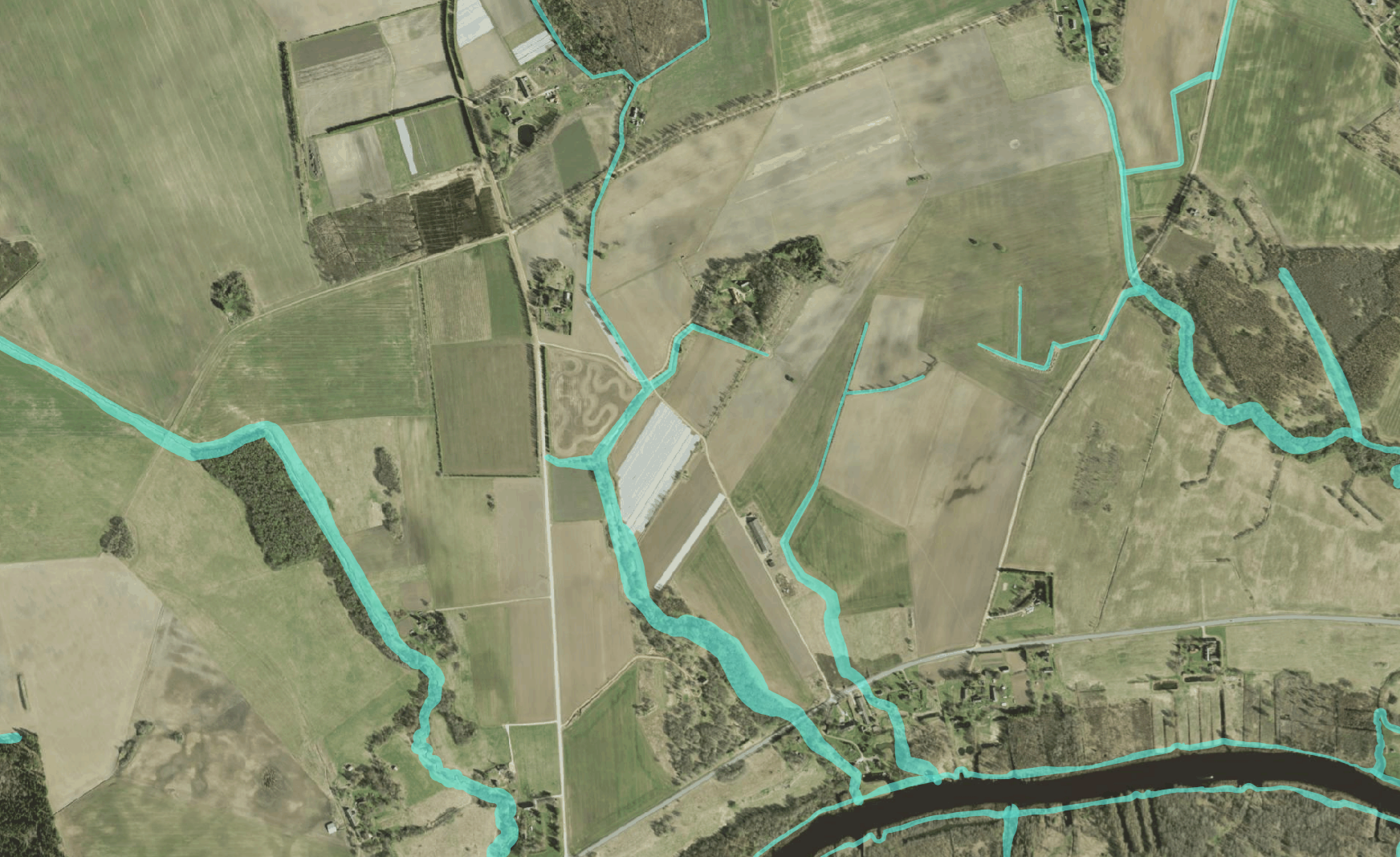
Planning Riparian Buffer Strips
Riparian buffer strips are multifunctional landscape elements that provide a wide array of ecosystem services, ranging from filtering surface water runoff along agricultural water bodies to improving microclimate and creating habitats. From the perspective of reducing diffuse pollution, the nitrogen and phosphorus removal processes that occur in buffer strips are crucial. The effectiveness of a buffer strip depends primarily on its width and vegetation structure. Buffer strips can reduce the amount of particles entering water bodies via surface runoff by 67–90%, with the first 2–6 meters being the most effective.
To prevent and reduce surface water pollution, water protection zones have been legally established in Estonia. The extent of the water protection zone is stipulated by the Water Act and, depending on the water body, these are 1, 10, or 20 meters from the waterbody’s edge. Depending on environmental conditions (soil, relief), a buffer strip wider than the water protection zone is sometimes necessary.
However, establishing buffer strips is costly and, from the perspective of farmers, not a particularly practical activity, as the land under the buffer strips is excluded from agricultural production. Therefore, it is reasonable to identify the places within water protection zones where there is the greatest risk of nutrients being carried from fields into water bodies. This can be done based on soil and relief characteristics. Generally, the risk of nutrient runoff into water bodies is higher on steeper slopes and clay soils.
We have calculated, based on soil and relief characteristics, how wide a buffer strip would be recommended if there is farmland along a water body. Buffer strips have been calculated for the edges of all water bodies with a water protection zone obligation, but if there is no farmland there, a buffer strip may not be necessary at all.
See the recommended buffer strip widths in the Estonian environmental data cube application or use the WMS service (https://maps.landscape-geoinformatics.org/geoserver/veemajandus/wms) to display them in a GIS program (ArcGIS or QGIS).
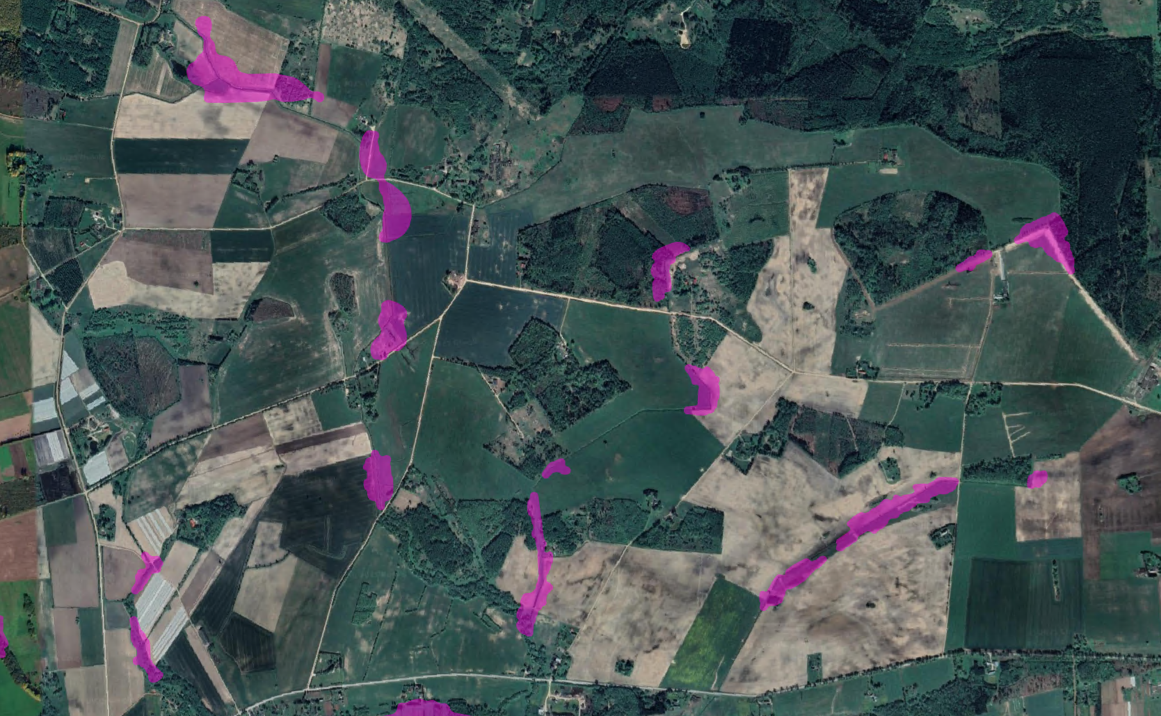
Planning Wetland Restoration in Agricultural Landscapes
Wetlands are one type of nature-based solution that can be skillfully used in landscape planning to reduce the amount of nutrients in water bodies. The territory of Estonia has historically been quite densely covered with wetlands, and over the last couple of centuries, we have intensively drained them. However, in many places on agricultural land, around streams and ditches, former wetlands are still noticeable in the landscape, and often crops may not grow well there due to persistent waterlogging. Such areas may be suitable for the restoration of small wetlands. Within the framework of this project, we have identified, using various map layers, those areas that would be suitable for wetland restoration on streams/ditches.
See the areas suitable for wetland restoration on the banks of water bodies from the Estonian environmental data cube application or use the WMS service (https://maps.landscape-geoinformatics.org/geoserver/veemajandus/wms) to display them in a GIS program (ArcGIS or QGIS).
Identifying Ditches with Deep Learning
Estonia is densely covered with drainage ditches, and knowing their precise location is important for both estimating greenhouse gas emissions and nutrient runoff. Generally, nutrient runoff is greater from agricultural landscapes with a denser ditch network because nutrients reach water bodies faster from the fields. Although the Estonian Topographic Database (Estonian Land and Spatial Development Board) is very detailed and comprehensive, many drainage ditches are still missing from it. In collaboration with several projects (including this project), we developed a deep learning model that allows for the identification of ditches from elevation models.
Read more in the Novaator article.
Outreach
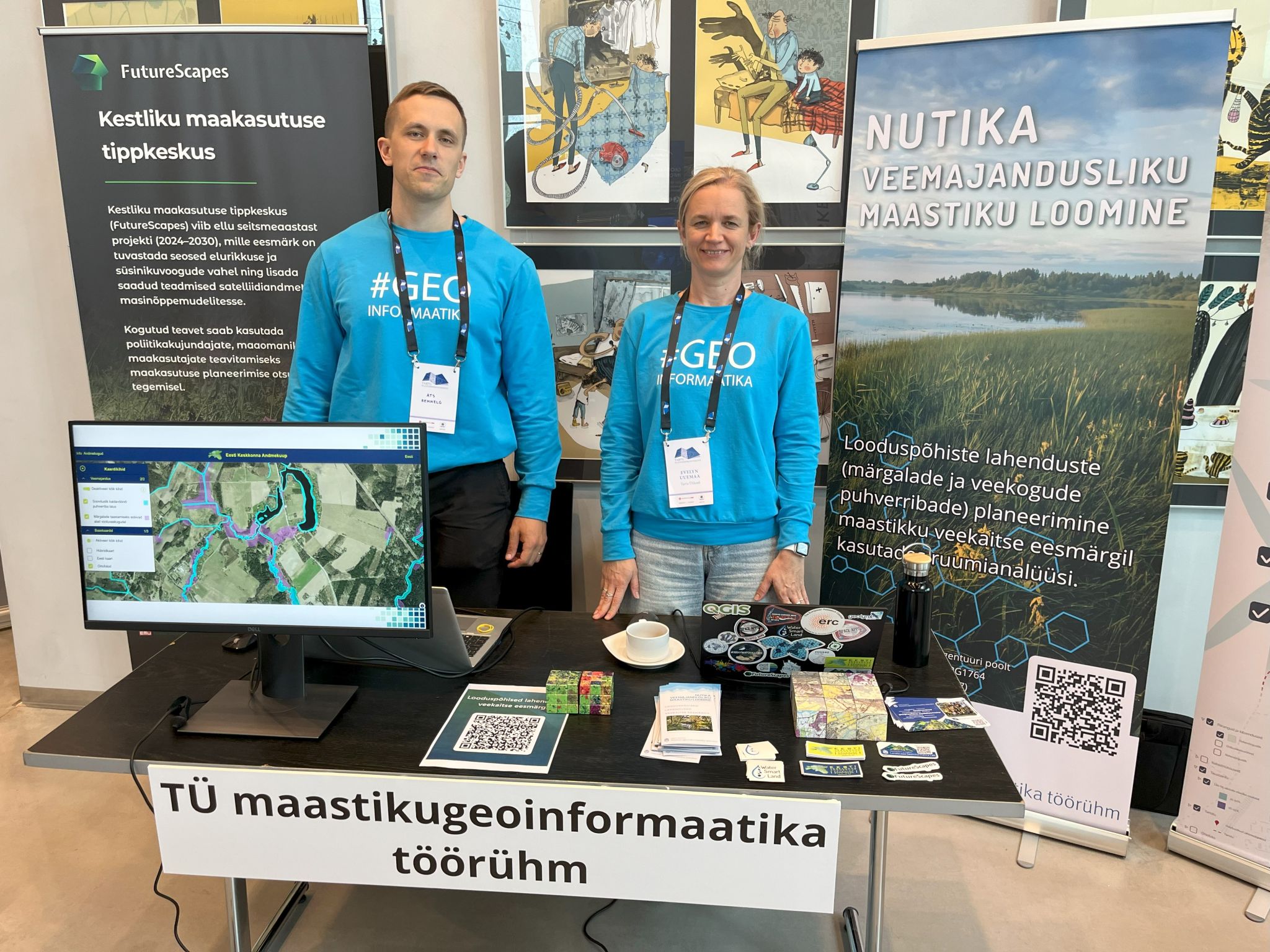
On 15 & 16 May 2025 the Landscape Geoinformatics Lab presented the initial development of the Estonian Environmental Data Cube portal (https://geokuup.ee/) at the Estonian Spatial Planning Conference 🗺️. The portal aims to provide a structured framework for accessing and analyzing environmental data 📊 relevant to spatial planning initiatives.
We also demonstrated spatial layers designed to inform the strategic implementation of nature-based solutions, specifically targeting wetland 🏞️ and riparian buffer strip 🌱 restoration and creation.
Publications
-
Kmoch, Alexander; Sahr, Kevin; Chan, Wai Tik; Uuemaa, Evelyn (2025). IGEO7: A new hierarchically indexed hexagonal equal-area discrete global grid system. AGILE: GIScience Series, 6, 1−6. DOI: 10.5194/agile-giss-6-32-2025.
-
Uuemaa, Evelyn; Virro, Holger; Muru, Merle (2025). Tehisaru aitab Eesti teadlastel kaardistamata kuivenduskraave tuvastada. Novaator.
-
Virro, Holger; Kmoch, Alexander; Lidberg, William; Muru, Merle; Chan, Wai Tik; Moges, Desalew Meseret; Uuemaa, Evelyn (2025). Detection of drainage ditches from LiDAR DTM using U-Net and transfer learning. Big Earth Data, 1−12. DOI: 10.1080/20964471.2025.2491177.
-
Kmoch, Alexander; Harrison, Clay Taylor; Choi, Jeonghwan; Uuemaa, Evelyn (2025). Spatial autocorrelation in machine learning for modelling soil organic carbon. Ecological Informatics, 103057. DOI: 10.1016/j.ecoinf.2025.103057.
-
Moges, Desalew Meseret; Virro, Holger; Kmoch, Alexander; Cibin, Raj; Rohith A. N.; Martínez-Salvador, Alberto; Conesa-García, Carmelo; Uuemaa, Evelyn (2024). Streamflow Prediction with Time-Lag-Informed Random Forest and Its Performance Compared to SWAT in Diverse Catchments. Water, 16 (19), 2805. DOI: 10.3390/w16192805.
-
Jemeljanova, Marta; Kmoch, Alexander; Uuemaa, Evelyn (2024). Adapting machine learning for environmental spatial data – A review. Ecological Informatics, 81, 102634. DOI: 10.1016/j.ecoinf.2024.102634.
-
Marco Minghini, Evelyn Uuemaa, and Marco Ciolli (Ed.) (2024). Preface: Proceedings of the FOSS4G 2024 Academic Track – Digital Revolution. DOI: 10.5194/isprs-archives-XLVIII-4-W12-2024-1-2024.
-
Kmoch, A.; Bovy, B.; Magin, J.; Abernathey, R.; Coca-Castro, A.; Strobl, P.; Fouilloux, A.; Loos, D.; Uuemaa, E.; Chan, W.T.; Delouis, J.M.; Odaka, T. (2024). XDGGS: A community-developed Xarray package to support planetary DGGS data cube computations. ISPRS Archives, 48, 75−80. DOI: 10.5194/isprs-archives-XLVIII-4-W12-2024-75-2024.
-
Toming, Kaire; Liu, Hui; Soomets, Tuuli; Uuemaa, Evelyn; Nõges, Tiina; Kutser, Tiit (2024). Estimation of the Biogeochemical and Physical Properties of Lakes Based on Remote Sensing and Artificial Intelligence Applications. Remote Sensing, 16 (3), 464. DOI: 10.3390/rs16030464.
-
Moges, Desalew Meseret; Virro, Holger; Kmoch, Alexander; Cibin, Raj; Rohith A. N.; Martinez-Salvador, Alberto; Conesa-Garcia, Carmelo; Uuemaa, Evelyn (2023). How does the choice of DEMs affect catchment hydrological modeling? Science of The Total Environment, 892, 164627. DOI: 10.1016/j.scitotenv.2023.164627.
-
Burdun, Iuliia; Bechtold, Michel; Aurela, Mika; De Lannoy, Gabrielle; Desai, Ankur R.; Humphreys, Elyn; Kareksela, Santtu; Komisarenko, Viacheslav; Liimatainen, Maarit; Marttila, Hannu; Minkkinen, Kari; Nilsson, Mats B.; Ojanen, Paavo; Salko, Sini-Selina; Tuittila, Eeva-Stiina; Uuemaa, Evelyn; Rautiainen, Miina (2023). Hidden becomes clear: Optical remote sensing of vegetation reveals water table dynamics in northern peatlands. Remote Sensing of Environment, 296, 113736. DOI: 10.1016/j.rse.2023.113736.
Funding agency: Estonian Research Council